Forecast for the Provo Area Mountains

Bo Torrey
Issued by Bo Torrey on
Wednesday morning, March 11, 2026

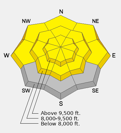
The overall avalanche danger is MODERATE. On upper-elevation slopes, multiple days of strong winds blowing from the west are creating heightened avalanche conditions on specific terrain features. Slabs of wind-drifted snow may be hard or soft, and more than 12 inches thick. Approach all upper-elevation slopes with caution, and carefully evaluate slopes steeper than 30 degrees where the wind has drifted snow.

As the sun comes out and daytime temperatures warm snow surfaces, the potential for wet-snow avalanches will rise. Avoid travel on or beneath steep slopes when surface conditions become wet and unsupportable.

It is unlikely that you will trigger an avalanche that breaks on a persistent weak layer; however, given the potential consequences of a large avalanche, you should evaluate the terrain and snow carefully. This problem is more likely to be triggered on steep, rocky slopes where coverage is thinner, and it would be easier to impact the weak layer.

Grey on the danger rose indicates there is little to no snow in these locations.

Low
Moderate
Considerable
High
Extreme
Learn how to read the forecast here
Weather and Snow

Yesterday, strong winds blowing from the west were drifting snow along the highest ridges, with large plumes observed along the Timpanogos ridgeline. The cloud cover and breezy conditions helped keep the snow surface cool at mid and upper elevations.

Overnight, temperatures dropped into the teens and low 20s °F. Yesterdays strong winds have and are currently blowing from the SW 10-25 mph with gusts into the 30s on Cascade Peak.

Today, skies will be mostly sunny. Mountain temperatures warm into the 40s °F at low- and mid-elevations and 30s °F at upper elevations. Winds will be strongest along the upper elevation ridgelines and blow from the WNW 15-35 mph with gusts into the 50s.

Thinner snowpack and concerning PWL structure on a mid-elevation NE aspect in Snake Creek. Photo: Champion

On Monday, Nikki, Drew, and I each traveled to a different part of the Provo forecast zone. Nikki was near Pole Line Pass and found a surprisingly shallow snowpack where the Dry January Facet layer remains weak and buried beneath a thin, hard slab. Observation HERE. Photo above.

Drew was on Mt. Timpanogos and found a very structured snowpack with several crusts and strengthening facets beneath. Observation HERE.

I traveled up the South Fork near Cascade and beneath the new snow found a thick and supportable crust. The DJL was located directly beneath the crust in this area, which was unreactive, moist, and showed signs of gaining strength. Observation HERE.

Recent Avalanches

There were no reports of avalanches from the Southern Wasatch yesterday. On Monday, both natural and human-triggered wet-loose avalanches occurred on steep sunny slopes. As the surface snow becomes wet and loose, it easily slides on top of the thick crusts beneath.

Avalanche Problem #1
Wind Drifted Snow
Type
Location
Likelihood
Size
Description

Strong ridge-top winds blowing from the west will remain steady through the day. This will create pockets of stiff slabs in upper elevation terrain that may be sensitive to the additional weight of a rider. Avoid any slope steeper than 30-degrees where you observe obvious signs of wind drifting. The snow surface may appear rough and textured, with obvious changes in the surface hardness.

Avalanche Problem #2
Wet Snow
Type
Location
Likelihood
Size
Description

Overnight, below-freezing temperatures created a thick melt-freeze crust on the surface at all elevations. As the daytime temperatures warm and the surface crust deteriorates, the potential for wet-snow avalanches will rise. On Monday, the wet surface snow easily slid atop the firm crust beneath. Although generally small in size, wet and heavy snow can quickly entrain more mass, pick up speed, and be difficult to escape. Avoid traveling on steep slopes where you find wet and unsupportable conditions, especially near terrain traps where a small avalanche could have outsized consequences.

Avalanche Problem #3
Persistent Weak Layer
Type
Location
Likelihood
Size
Description

The Dry January Layer (DJL) of faceted snow is 2-4 feet deep and buried by a strong slab and supportable crusts in most parts of the zone. The last reported human-triggered avalanche failing on the DJL occurred on February 21 in the Ant Knolls. Triggering an avalanche failing on the DJL is unlikely, and this problem is moving toward dormancy. The suspect terrain where you can still trigger a dangerous hard-slab avalanche failing on the DJL is on northerly aspects at upper elevations, where there is a thinner slab, such as a "repeater slope" that previously avalanched this season.

General Announcements

This information does not apply to developed ski areas or highways where avalanche control is normally done. This forecast is from the U.S.D.A. Forest Service, which is solely responsible for its content. This forecast describes general avalanche conditions and local variations always occur.