Avalanche Warning
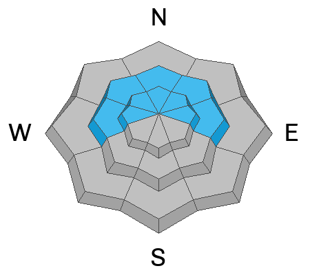
What: The avalanche danger for the warning area is HIGH today.
Where: The mountains of northern, central, southwestern, and southeastern Utah, including the Abajo Range, as well as southeastern Idaho.
Impacts: Recent heavy snow combined with strong wind has created widespread areas of unstable snow. Both human-triggered and natural avalanches are likely.
What to do: Avoid all avalanche terrain. Stay off of and out from under slopes steeper than 30°. Carry and know how to use avalanche rescue equipment. Find safer riding conditions on slopes less than 30° with no overhead hazard
Warning Times: Thursday, 2/19/26 at 6:00 AM MST through 6:00 AM MST Friday, 2/20/26
Avalanche Warning vs. Watch: The UAC upgraded our Avalanche WATCH to our first Avalanche WARNING of the season today. An Avalanche WARNING, the most severe avalanche alert product we have, is issued when large avalanches are certain or very likely in many areas and when unusually dangerous avalanche conditions exist. More info on each of these from Bruce Tremper and Drew Hardesty HERE.
Since Monday evening, an impressive series of storms has moved through the state. The strong southwest flow favored parts of the Provo area, including the Timpanogos Divide and Provo Canyon. When the flow shifted more northwesterly, it didn’t do much for the Provo area mountains, but a bit more precipitation did make its way through, adding roughly 5 inches. Final storm totals as of this morning are:
Today, the storm has moved out, leaving a few light showers with little accumulation. Snowfall should stay under an inch during the day. Temperatures will climb into the upper teens to low 20s, with southwesterly winds blowing 10 to 15 mph along most upper-elevation ridgelines, gusting to 25 mph and up to 35 mph at the highest peaks.
Another system arrives this evening, mainly impacting central and southern Utah, with northern Utah on the edge and likely seeing lower totals. Snow should begin between 6 and 10 pm, with the best chance for steadier snowfall Friday afternoon before drying out Friday night. This flow could dip south of the central Wasatch, but the southwest flow could bring another decent hit to the Provo area mountains.
In the Provo area mountains, heavy snow with moderate southwest winds created dense, fast snow and early wind slabs on southeast aspects. Slab avalanches in UFO Bowls 4 and 5 were remotely triggered from a brushy meadow below, propagating 600’ up to the ridge and along the ridge for roughly 1,000’, with very touchy conditions.
Just north of the Provo area mountains in the SLC region, yesterday saw very unstable backcountry conditions, with widespread soft slab avalanches 20 inches to 3 feet deep reported on north through southeast-facing slopes between 8,200 and 10,000 feet. Travel was hazardous, including a close call near Nutty Putty where one party was partially and fully buried but fortunately uninjured.
You can view all recent observations here.