Forecast for the Provo Area Mountains

Bo Torrey
Issued by Bo Torrey on
Saturday morning, February 14, 2026

A tricky MODERATE avalanche danger exists in the mid and upper elevations, and primarily on slopes with previous deposits of wind-drifted snow. You can trigger soft slabs up to 2 feet thick and more than 200' wide. These are conditions for avalanche accidents - avalanches on persistent weak layers (PWLs) are notoriously tricky, and avalanches can be triggered from a distance.

Warm daytime temperatures and strong direct sunlight will increase the possibility of triggering a wet snow avalanche throughout the day. Avoid travel on sunny slopes, where you find wet and heavy snow. Wet snow avalanches can start small and quickly pick up speed and volume as they travel down slope.

Low
Moderate
Considerable
High
Extreme
Learn how to read the forecast here
Special Announcements

Join the UAC for the first "Stay and Play Avalanche Course" at Bear River Lodge in the Uintas, March 19th-22nd. This course is designed for snowmobilers by snowmobilers, where you will learn avalanche rescue, riding skills, and how to survive in the backcountry. Come enjoy all the luxury offerings at Bear River Lodge and improve your skills along the way.

You can find details and sign up HERE.

Weather and Snow

This morning, temperatures are 15-20°F, and winds are blowing from the west, averaging 5-15 mph with gusts in the 20s mph at upper elevations.

Today, high thin clouds build overhead through the afternoon. Temperatures warm into the low 40s °F. Wind blowing from the southwest increases to 10-20 mph with gusts in the 30s by early evening.

Recent Avalanches

We did not receive reports of avalanches from the Southern Wasatch, but there have been several avalanches from the Central Wasatch, where similar snowpack conditions exist. Recap from the north below:

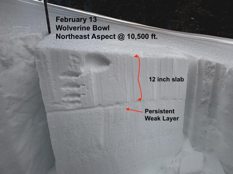
Yesterday, several human-triggered avalanches were reported in the backcountry, with rumors of 2 close calls in terrain near Brighton. Avalanche activity over the last several days has been most common on upper-elevation north through east-facing slopes where the wind deposited additional snow. All of these soft slabs failed at the new/old interface, where exceptionally weak faceted snow exists from the January drought. These slopes may not appear obviously wind-loaded, as snowfall from Thursday fell without much wind and covered up the usual indicators of wind-drifting.

  • White Pine-Dog Dish- northeast aspect at 9600 feet, skier-triggered, 15 inches deep by 200 feet wide, failing on facets and propagating wide.
  • Brighton- Pioneer Peak- northeast aspect at 10,200 feet, snowboarder triggered, 12 inches deep by 50 feet wide, failing on facets.
  • Park City Ridgeline-Scotts Hill- north aspect at 9900 feet, skier-triggered, 2 feet deep by 25 feet wide, failing on facets

While the recent storm snow has begun to settle and sensitivity slowly decreases, the slab is now more cohesive and has shown it can propagate widely.

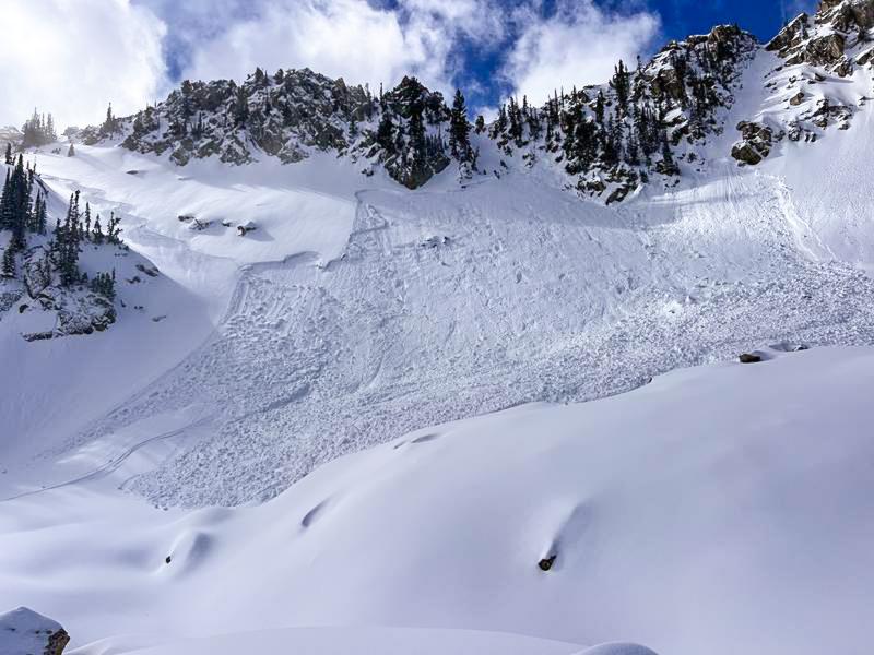
A skier-triggered avalanche in upper White Pine failed on a layer of faceted snow and propagated widely.

You can view all recent observations here.

Avalanche Problem #1
Persistent Weak Layer
Type
Location
Likelihood
Size
Description

Recent storm snow has buried weak facets from the January dry spell, creating a tricky slab problem. Avalanches 8 to 18 inches deep are being reported daily and are propagating wider as the snow settles and the slab stiffens. Some of these avalanches have been triggered from a distance.

Avalanches are most likely to fail on slopes where wind deposited additional snow; however, the signs of obvious wind-drifting we normal look for may not be present as snowfall from Thursday fell without much wind and covered our usual indicators. Slopes where you find a cohesive slab of snow above this layer of sugary facets is where you can trigger an avalanche up to 2 feet thick and more than 200 feet wide. This structure is easy to identify with the naked eye if you get your shovel out and dig down just a couple feet. See example below.

Avalanche Problem #2
Wet Snow
Type
Location
Likelihood
Size
Description

Warm daytime temperatures and strong sun may create conditions for wet snow avalanche through the day. Slopes where surface snow has become wet and heavy are where you can trigger a wet snow avalanche. These avalanches may start small and be slow-moving, but can quickly pick up speed and grow in size as they begin to slide downhill and entrain more snow.

Avoid terrain traps like chutes, gullies, and cliffs where small avalanches can increase consequences and pile up significant avalanche debris.

Additional Information

Learn more about Persistent Weak Layers in the video above -

General Announcements

This information does not apply to developed ski areas or highways where avalanche control is normally done. This forecast is from the U.S.D.A. Forest Service, which is solely responsible for its content. This forecast describes general avalanche conditions and local variations always occur.