Check out our Holiday Auction - Sign Up for the Utah Snow and Avalanche Workshop (USAW)

Forecast for the Provo Area Mountains

Trent Meisenheimer
Issued by Trent Meisenheimer on
Sunday morning, November 3, 2024
Updated 1:10 PM on Sunday, November 3.
The northwest wind was moving snow across the most upper-elevation terrain, and I imagine small wind slabs could be found in very exposed areas. Otherwise, the snowpack was right-side up, with rocks and shallow snow being the most significant hazards. Winter has begun.

If you're heading to a resort for early-season turns, check uphill policies for each resort.
Low
Moderate
Considerable
High
Extreme
Learn how to read the forecast here
Special Announcements
SAVE THE DATES!
Monday, November 4 - 17th Annual Professional Snow and Avalanche Workshop (PROSAW) - Information and tickets are available here.
Saturday, December 7 - 17th Annual Utah Snow and Avalanche Workshop (USAW) - Information and tickets available here.
Weather and Snow
In the past 24 hours, we've received roughly 6.5 inches of new snow, which contains 0.62 inches of snow water equivalent (Upper Cottonwoods). The wind has been blowing from the northwest, averaging 5-10 mph with gusts into the 20s across the upper elevations.
As the storm exits today, we will see partly cloudy skies with the occasional snow shower today and Monday. On Tuesday, another storm is on tap, with hopefully another 3-6 inches of new snow. This storm will also usher in some cold air Tuesday into Wednesday before it closes off into a closed low that spins down in the four corners area through the weekend. The current GFS model run shows more storms through mid-month (fingers crossed).
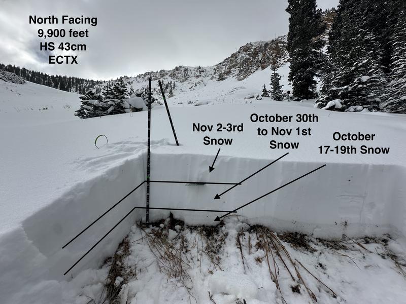
Snow depths are roughly 6-16 inches above about 8,500'. The snowpack consists of three layers (see picture). The bottom layer in the photo is snow that fell from October 17th through the 19th. We theorized that this layer only exists around 9,000' on shady aspects. Below that, it's pretty spotty and melted out. Where we dug at 9,900 feet, this layer is crusted and not faceted.
On top of that layer is our October 30th through November 1st storm, and then over that layer is the most recent overnight snowfall (6.5" with 0.62 H20). The total height of the snowpack here was roughly 43 cm.
We did two extended column tests that were negative (no propagation).
Recent Avalanches
Find all recent observations HERE.
Ad
Additional Information
It’s never too early to start thinking about avalanches. Here are a few things to consider doing:
  • Learn online. We have over 5 hours of free online learning at the Know Before You Go website
  • Check out the upcoming in-person Know Before You Go events HERE
  • Sign up for an on-snow class
  • Check out the UAC's education progression HERE
  • Get your avalanche rescue gear ready for winter. Put fresh batteries in your transceiver and update the firmware. Inspect your shovel and probe. Get your airbag backpack ready by possibly doing a test deployment and updating the firmware if it is an electric version or getting your canister refilled if it's not electronic.