Forecast for the Ogden Area Mountains

Bo Torrey
Issued by Bo Torrey on
Thursday morning, February 26, 2026

Avalanche conditions are dangerous. Very large, natural avalanches occurred yesterday, and more are possible today. The avalanche danger is CONSIDERABLE on all aspects and elevations, and human-triggered avalanches are likely. Avoid travel on and beneath slopes steeper than 30°.

Warm temperatures, rain on snow, and strong winds at the upper elevations are creating tricky conditions. Careful snowpack evaluation, cautious route-finding, and conservative decision-making are essential.

Low
Moderate
Considerable
High
Extreme
Learn how to read the forecast here
Weather and Snow

Yesterday, 1-2 inches of precipitation fell mostly as rain below 9000 feet. Above that, 2-4 inches of dense snow accumulated. Even north-facing slopes at upper elevations feet saw wet snow and may have a thin surface crust this morning. Strong ridgetop winds blowing from the west were drifting snow, creating stiff wind slabs.

Overnight, skies were cloudy, and temperatures remained warm, with freezing levels dropping to around 8000 feet. Winds continued to blow from the west at 10-20 mph with gusts into the 30s. Expect the superficial refreezes to soften quickly this morning.

Today, lingering light rain and snow showers this morning will gradually clear out and lead to partly cloudy skies. Temperatures climb into the upper 30s and low 40s °F, though ridgetop temperatures may feel much cooler with wind chill. Winds will continue to blow from the west, 10-20mph, with gusts reaching into the 30s along the ridge crest before beginning to decrease through the day.

Recent Avalanches

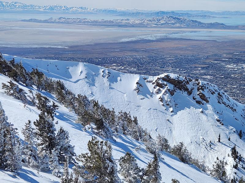
There were no reported avalanches from the backcountry yesterday, but ski area avalanche teams reported large wet slab avalanches failing on PWL and gouging down near the ground. Below 7500 feet, the snowpack is completely saturated and unsupportable to the ground.

Three people were killed in separate avalanche accidents in the past week, with a fourth in critical condition.

  • Wednesday 2/18 Ant Knolls, Wasatch Back Fatality — Snowmobiler. Preliminary report HERE.
  • Thursday 2/19 Rock Garden, BCC (Brighton Backcountry) Fatality — 11-year-old skier. Preliminary report HERE.
  • Saturday 2/21 Butler Basin, BCC - 1 Injured, 1 in Critical Condition — Backcountry skiers. Preliminary report HERE.
  • Sunday 2/22 Caribou Basin, Wasatch Back Fatality — Snowbiker. Preliminary report HERE.

All of these accidents involved slab avalanches 2-3' thick and up to 500' wide failing on weak faceted snow, our January Dry Layer (JDL). There's something else I want to point out - in nearly all of these and many other close calls, the individual or party triggered the avalanche from below while in gentle terrain. It's not enough to be on low-angle terrain: you can collapse the slope and pull the avalanche down on top of you.

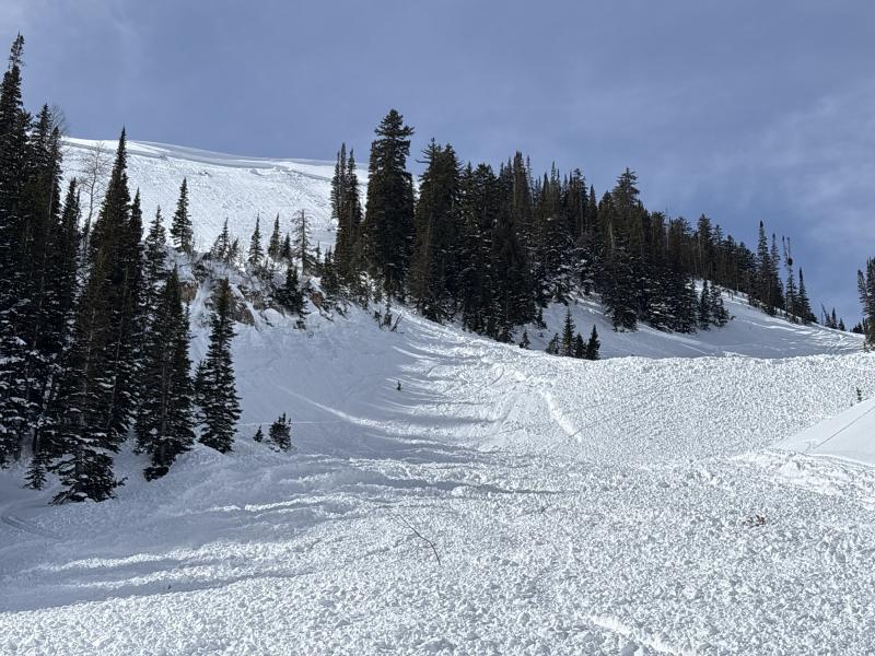
Very-large hard slab avalanche from Sunday's snowbike fatality in Caribou Basin near Midway. (photo: Torrey)

Avalanche Problem #1
Persistent Weak Layer
Type
Location
Likelihood
Size
Description

The DJL (Dry January Layer) is buried 1-3 feet beneath the surface. This layer is responsible for 3 avalanche fatalities, several accidents, and more than 60 reported avalanches. The situation has recently become more complex, as the overlying slab has grown increasingly strong and hard. The hardness and thickness of the slab allow it to behave as a shield, making it more difficult to impact the weak layer. As the slab has strengthened, it's led to very wide avalanches that connect through and around terrain features across a slope. In this situation, the common ECT snowpack test is unreliable and often provides falsely stable results. Cracking and collapsing are unlikely to be observed. This can lead to a false sense of stability and lure people into avalanche terrain. Discipline and patience are required right now.

Recent avalanche activity is the best indication of current conditions. Both large natural and human-triggered avalanches yesterday point towards the high-consequence nature of this problem.

Large natural avalanche near Thurston Peak over the weekend.

Avalanche Problem #2
Wet Snow
Type
Location
Likelihood
Size
Description

Warm temperatures and significant rain on snow are creating conditions for wet snow avalanches on all aspects and elevations. Yesterday, both wet loose avalanches running on the surface and wet slabs failing on the PWL occurred.

Avalanche Problem #3
Wind Drifted Snow
Type
Location
Likelihood
Size
Description

Strong wind blowing from the west, combined with dense snow from yesterday are creating thick, stiff slabs along upper elevation ridges. These slabs may be stubborn to trigger and could break above you and pull into lower-angle slopes. Any wind slab triggered today has the potential to step down, resulting in a much deeper and wider avalanche that breaks on the persistent weak layer.

Additional Information

One needs to understand runout and alpha angles if traveling in the mountain environment. Chris Benson caught this footage of a very close call near Red Mountain Pass in Colorado over the weekend. These are the sort of avalanches that have left three dead and one in the hospital in Utah.

Learn more about runout and alpha angles HERE and HERE.

General Announcements

This information does not apply to developed ski areas or highways where avalanche control is normally done. This forecast is from the U.S.D.A. Forest Service, which is solely responsible for its content. This forecast describes general avalanche conditions and local variations always occur.