Forecast for the Ogden Area Mountains

Drew Hardesty
Issued by Drew Hardesty on
Thursday morning, January 8, 2026

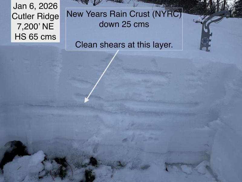
Areas of CONSIDERABLE exist for triggering a lingering soft or hard slab of wind drifted snow in the upper elevations. A MODERATE danger exists on all aspects at the mid and upper elevations for triggering an avalanche in the new snow. While triggering or encountering loose dry sluffs in the new snow will be most apparent, it's the lingering hard slab that will do you in. Extra Caution is advised in the wind zone.

The low risk - high reward choice is to ride excellent powder on slopes less than 30° in steepeness.

Low
Moderate
Considerable
High
Extreme
Learn how to read the forecast here
Special Announcements

Be mindful of avalanche workers and SAR personnel - IF YOU TRIGGER an avalanche near a ski area, please report it to the ski patrol dispatch. Rescue personnel don’t want to be subjected to dangerous conditions if the scene is clear. More on this in Backcountry Emergency Protocols.

Snowbasin Resort Dispatch-(801-620-1017)

Powder Mountain Dispatch- (801-745-3772 ext 3).

Weather and Snow

Now this is a good old fashioned cold front!

As of 6AM, storm totals are 6-8" of cold, right-side-up snow. And it should keep snowing off and on throughout the day. Even the trailheads are finally getting some snow - the Ben Lomond trailhead has up to 8" of new. Temps are in the upper teens up high and the mid-20s elsewhere...and dropping. Winds are new generally light from the northwest except along the highest ridgelines where they're blowing 15-20mph. Should be an excellent powder day.

I hate to say, but Get it while you can, because we go high and dry after this storm. The weekend will have sunny skies and generally fair conditions. Snow coverage is creeping up with these last couple storms, with snow depths up to 40-50" in the high country.

UAC forecaster Greg Gagne toured up the Cutler Ridge on Tuesday and his report can be found HERE

Read all backcountry observations here.

Recent Avalanches

Ski area control teams reported triggering both loose dry and soft and hard slabs of wind blown snow in the upper elevations yesterday.

Avalanche Problem #1
Wind Drifted Snow
Type
Location
Likelihood
Size
Description

With multiple days of elevated winds, you'll encounter lingering soft and hard wind slabs in the mid and upper elevations, but these will be hidden beneath the new snow. My old boss Bruce Tremper used to call it 'sucker snow' because you'd see the powder but not the obvious wind slabs. Remember that hard slabs will allow you to get well onto the slab before you trigger the thing where it tapers down like a tear drop....and unfortunately they rarely show signs of cracking and collapsing prior to relase.

Recent slabs of wind-drifted or new snow may step down 1-2'+ feet into the Christmas Eve rain crust (CERC), and could also step deeper into older facets near the ground, with avalanches exceeding 3+ feet possible but only along the highest elevations.

See Greg's video below showing some drifting along the Ben Lomond Ridgeline, and talking about the snowpack and depth he found on his tour yesterday.

Avalanche Problem #2
New Snow
Type
Location
Likelihood
Size
Description

New loose dry sluffs will move with provocation in the steeper terrain on all aspects. The new snow may have bonded poorly to the old snow surfaces and run naturally during any periods of high snowfall rates.

Avalanche Problem #3
Persistent Weak Layer
Type
Location
Likelihood
Size
Description

On Tuesday, Greg was traveling Cutler Ridge up to 8500' and found various weaknesses within graupel and around the Christmas Eve and New Year’s rain crust. While we haven’t seen activity on these layers recently in the Ogden area mountains, we have observed activity on both the facets above the crust and the facets at the ground in the Salt Lake area, and we know a similar structure exists at the upper reaches of Ogden.

These slides may be a warning that on many slopes with a persistent weak layer (PWL), the added weight of new and wind-driven snow could be enough to trigger larger avalanches in the Ogden area. The uncertainty of the pattern and locations should give pause.

Between 7,500 and 8,500’, the New Year’s Rain Crust (NYRC) has a layer of graupel. Greg was able to get some clean shears just above the NYRC, but also observed evidence of weaker crystals. Continue to watch for possible faceting above this crust.

General Announcements

This information does not apply to developed ski areas or highways where avalanche control is normally done. This forecast is from the U.S.D.A. Forest Service, which is solely responsible for its content. This forecast describes general avalanche conditions and local variations always occur.