Forecast for the Ogden Area Mountains

Nikki Champion
Issued by Nikki Champion on
Thursday morning, January 15, 2026

An overall LOW avalanche danger exists in the Ogden backcountry. The snow is mostly stable, and triggering an avalanche is unlikely. Still, we want to continue to watch for unstable snow on isolated terrain features.

Steep, rocky, or extreme north-facing and wind-loaded terrain at upper elevations, where snowpack depth is variable, would be the most suspect.

Small but predictable wet loose avalanches may release on sunny slopes with daytime warming. Remember, if the snow is becoming damp or unsupportable and you're seeing roller balls on any aspect or elevation, it's time to get out of there.

Low
Moderate
Considerable
High
Extreme
Learn how to read the forecast here
Weather and Snow

This morning, skies are clear, and a strong inversion is set up in the mountains, with trailhead temperatures in the mid 20s °F and ridgeline temperatures in the mid to upper 30s °F. Winds have transitioned to blow out of the west, averaging 5–10 mph, with gusts up to 20 mph along most ridgelines and up to 30 mph along the highest peaks.

Today, temperatures again warm into the upper 30s and low 40s °F. Winds stay out of the west for the remainder of the day, with gusts up to 30 mph.

Looking ahead, a ferocious mid-winter ridge stretching from Mexico to northern Canada sits over the western US, blocking any chance of precipitation for the next 7+ days. The big question for the Wasatch Front right now is how long these valley inversions will last. Odds are they hang on until a storm system shows up late next week. A storm on Friday could weaken the inversion, but the chances of a full mix-out remain low. Rejoice in being in the mountains and out of the valley inversion.

Recent Avalanches

There were no new avalanches reported from the Ogden backcountry on yesterday.

While things have been quiet on the avalanche front, we’ve received some excellent observations over the past few days, especially focused on dialing in questions around the persistent weak layer. Two solid observations came in from the Snowbasin periphery one from Taylor Canyon and one off Mt Allen where a similar snowpack structure and results to what Drew and I found on Tuesday were observed. We also received great photos and data points highlighting travel conditions along Cutler Ridge. See below.

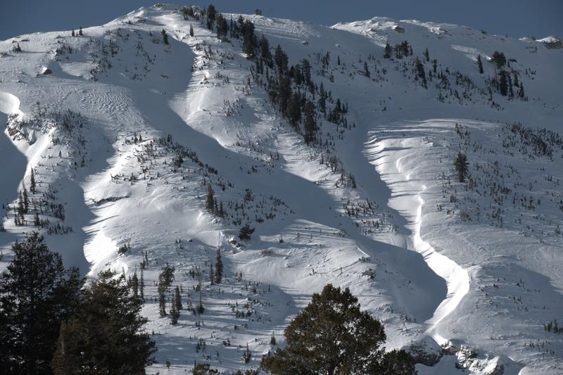
Ben Lomond Headwell - B. Dubovik

The most recent backcountry avalanche activity was reported on Sunday, when wet loose avalanches occurred. This included Derek DeBruin’s observation from Mt Ogden of large wet loose avalanches on west through southwest facing aspects.

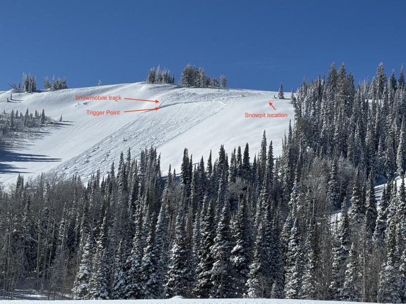
On Saturday, a snowmobiler triggered a wind slab avalanche on Whiskey Hill in the Monte Cristo area. Fortunately, the rider was able to ride off to the side.

We continue to receive many excellent, high-quality observations.

Avalanche Problem #1
Persistent Weak Layer
Type
Location
Likelihood
Size
Description

Recent field observations and reports from the Ogden area resorts indicate that facets still exist at the base of the snowpack on upper elevation northerly facing slopes, but the problem is currently "dormant". While the weak layer remains present, it is not showing overall signs of instability, and the likelihood of triggering it is low. This could change with additional loading from wind, water, or new snow.

While the overall likelihood is low, small avalanches are still possible in isolated features and extreme terrain. The most suspect terrain remains steep, north-facing slopes at upper elevations that have been recently wind-loaded.

Additional Information

Recent observations have highlighted some concerning travel trends in our zones. These comments aren't about judgment; they come from a place of shared concern for our community and everyone's safety.

It is a good time to refresh on the basics. Safe travel habits aren't just for 'high danger' days; they are the baseline techniques that reduce vulnerability for you and the groups around you.

The goal is margin. We treat safe travel as a strict, daily habit to build a margin for error. This ensures that even if the actual conditions turn out to be different than your assessment, your exposure to the consequences remains low.

  • Pick safe up tracks that utilize ridges and slopes less than 30 degrees.
  • One at a time- never expose more than one person at a time to avalanche-prone slopes
  • Travel with a partner- you can't dig yourself out. A good partner can help you make decisions and is essential if things go wrong.
  • Communicate- communication with your partners is the key to good decision-making.
  • Stay out of the way- Avalanches commonly flow into gentle, open terrain. Regroup in places where you're not exposed.
General Announcements

This information does not apply to developed ski areas or highways where avalanche control is normally done. This forecast is from the U.S.D.A. Forest Service, which is solely responsible for its content. This forecast describes general avalanche conditions and local variations always occur.