Forecast for the Moab Area Mountains

Dave Garcia
Issued by Dave Garcia on
Friday morning, March 27, 2026

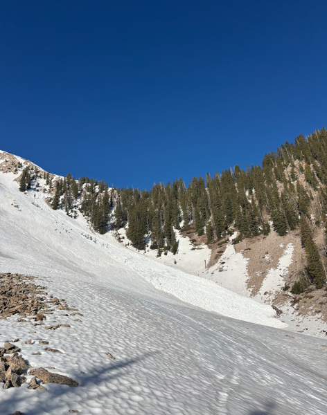
A MODERATE avalanche danger exists on all steep slopes that still hold snow, with human-triggered wet-loose and wet-slab avalanches possible. Extra caution is warranted on northerly aspects, where lingering faceted weak layers remain vulnerable to meltwater percolation. Complex, rocky, and extreme terrain is especially suspect. Signs like punchy, unsupportable, or sloppy wet snow point to increasing instability—avoid avalanche terrain where these conditions exist.

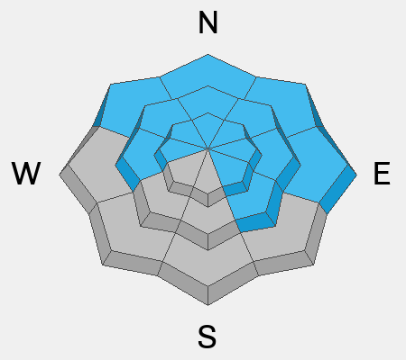
Gray on the rose indicates areas that are mostly clear of snow. Some variations occur.

Low
Moderate
Considerable
High
Extreme
Learn how to read the forecast here
Special Announcements

Geyser Pass Road Conditions: The road is melted down to dirt.

Grooming: Grooming is done for the season.

A new version the UAC's mobile app has been released with many new features and performance improvements. Download our app today, available on iPhone and Android.

Weather and Snow

24 Hour Snow: 0" 72 Hour Snow: 0" Season Total Snow: 75" Depth at Gold Basin: 14"

Winds on Pre-Laurel Peak: Light NW Temp: 33°F

Weather

Under clear skies, it is 33°F in Gold Basin. For today, skies will be clear, and daytime highs will reach 54°F at 10,000 feet. Winds will blow from the west-southwest 5 to 15 MPH. Temperatures will begin to gradually cool, but record high temperatures remain possible through Monday. Dry and windy conditions persist through the weekend. A pattern shift is expected next week. We may get a solid refreeze on Tuesday night.

General Conditions

Data is a little sparse this morning, but it appears that mountain temperatures dipped down to the freezing mark for a couple of hours. It's going to take more than that for the entire snowpack to truly freeze. Last night's colder temperatures should give the surface a good freeze, allowing for a short window of easy travel conditions this morning. Sam Van Wetter and company were out and about yesterday, and reported some decent turns in between "firm glassy snow and drop-to-the-rocks postholes."

Solar aspects are largely bare and no longer skiable. At lower elevations, northerly slopes are a sloppy mix of wet, unsupportable snow and collapsing facets. Higher elevation north-facing terrain is seeing only a thin, superficial refreeze, with a very short window for supportable travel. This is the same terrain where our wet avalanche problem remains most concerning.

Wet-loose avalanches will once again be possible on all slopes. In addition, wet-slab avalanches are possible, with the greatest concern on NW–N–E aspects near and above treeline.

See all Moab observations here.

Snowpack and Weather Data

Wind Station on Pre-Laurel Peak (11,400')
NWS forecast for the La Sal Mountains.
Recent Avalanches
A good sized loose-wet avalanche on the east face of South Mt. Sam Van Wetter photo.
See the full avalanche database.
Avalanche Problem #1
Wet Snow
Type
Location
Likelihood
Size
Description

Human-triggered wet-loose and natural wet-slab avalanches remain possible on any slope that still holds snow. The danger is notably lower on solar aspects, where you’re most likely to encounter small, loose wet activity. The primary concern remains wet-slab avalanches, with the greatest likelihood on slopes facing the north half of the compass.

On many slopes, meltwater has already percolated through the entire snowpack to the ground. In these areas, expect “trapdoor” conditions—where you can suddenly punch through the surface—and the possibility of the entire snowpack releasing beneath you. At upper elevations on northerly aspects, meltwater may not yet have fully penetrated the snowpack, as observed in Tuesday's fieldwork, keeping the potential for wet-slab avalanches elevated in the coming days.

Even if the surface experiences a shallow overnight refreeze, meltwater will continue to move through the snowpack until temperatures drop below freezing for a sustained period. Wet slabs are notoriously difficult to predict, and under these conditions, the risk outweighs the reward of traveling in avalanche terrain.

Additional Information
General Announcements
This forecast is from the U.S.D.A. Forest Service, which is solely responsible for its content. This forecast describes general avalanche conditions and local variations always occur.