24 Hour Snow: 0" 72 Hour Snow: 0" Season Total Snow: 75" Depth at Gold Basin: 30"
Winds on Pre-Laurel Peak: NW 15-25 Temp: 30°F
Weather
Look for sunny skies, warm temperatures, and continued breezy conditions today. Winds from the northwest will average 10-20 mph along ridge tops with gusts into the 30's, and high temperatures will be around 40°F at 10,000'. Temperatures will be 10 degrees warmer tomorrow as the heat wave begins, and they will increase by about 5 degrees a day. Record breaking temperatures are expected by the end of the week with highs in excess of 60°F at 10,000 feet.
General Conditions
Today will be your last opportunity to sniff out some corn snow before warm temperatures, and the lack of overnight freezes finish it off. The upcoming heatwave will be dire for our already meager snowpack. It's currently very shallow, and most south aspects are bare ground. Northerly aspects hold 3-4 feet of snow where they haven't been wind scoured off, and the surface varies from crusted to mashed potatoes. In addition, weak layers of dry, faceted snow persist beneath the surface, and in some cases, hard slabs sit on top, particularly in areas above treeline.
We have a fair amount of uncertainty as to how the heat will affect avalanche conditions but it's certain that the danger will rise. Concerns are twofold: 1) The dramatic rise in heat will re-activate persistent weak layers in the snowpack, and 2) we may see a wet slab avalanche cycle. Wet slabs are notoriously difficult to predict but they can be very destructive. The bottom line is that overall lousy conditions, combined with a dangerous and unpredictable avalanche hazard, hardly warrant being in the mountains later this week.
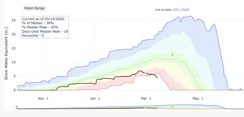
In case you are wondering, this is officially the worst snowpack ever at 36% of normal. The black line is this season and just dropped below the historical minimum. We generally reach peak snowpack in mid April, this year it was late February. Uggh.
See all Moab observations here.
Snowpack and Weather Data


