Forecast for the Moab Area Mountains

Dave Garcia
Issued by Dave Garcia on
Thursday morning, March 12, 2026

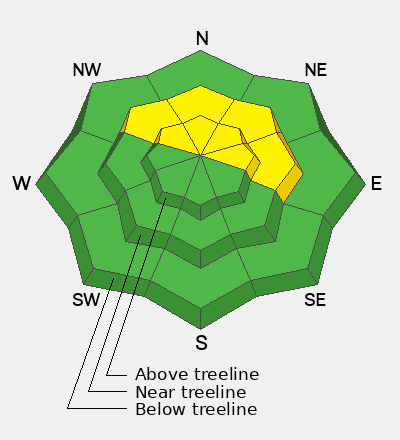
The avalanche danger is MODERATE on steep slopes near and above treeline facing NW-N-E. Human-triggered hard slab avalanches 2–4 feet deep, failing on a buried persistent weak layer, remain POSSIBLE in this terrain. If triggered, these avalanches could step down and involve the entire season’s snowpack.

While the likelihood of triggering an avalanche has decreased, the consequences remain serious. Personally, I will continue to avoid steep northerly aspects near and above treeline.

Low
Moderate
Considerable
High
Extreme
Learn how to read the forecast here
Special Announcements

Geyser Pass Road Conditions: The road was not plowed after the last storm. Expect a little snow and ice up high, and muddy conditions as the day heats up.

Grooming: No grooming is scheduled. Cover is thin, and conditions are rough.

Mountain Film on Tour returns to Star Hall in Moab on Saturday, March 14. Tickets are available online and all proceeds benefit UAC Moab. We look forward to seeing you all there!

All four accident reports are completed from the deadly mid-February week in northern Utah. Our sincerest condolences to all of those affected.

Weather and Snow

24 Hour Snow: 0" 72 Hour Snow: 0" Season Total Snow: 75" Depth at Gold Basin: 31"

Winds on Pre-Laurel Peak: NW 15 G 25 Temp: 23°F

Weather

Under clear skies, it is 23°F in Gold Basin this morning. For today, expect sunny skies and daytime highs around 42°F at 10,000 feet. Winds from the west will blow 15-20 MPH. Gusty winds and warm temperatures are the story for the remainder of the week and the weekend. High temperatures in the mountains will reach the low 50s°F by Saturday.

General Conditions

The best game in town right now is spring skiing on solar aspects. On Tuesday, Brooke and I found nice corn skiing on mid and upper-elevation southeast aspects. The mountains got a solid overnight refreeze. Heading for sunny slopes is a great way to avoid the current avalanche problem, and you can score some good turns while you're at it. Polar aspects will offer a grab bag of crusts and mashed potato like snow.

The greatest threat from avalanches continues to be on northerly aspects near and above treeline, where hard slabs exist over layers of weak, dry, faceted snow. This is a notoriously unpredictable setup that offers little to no warning before failing. It’s a familiar pattern for seasoned La Sal skiers and riders. Avoiding steep northerly aspects continues to be the best strategy for safe skiing and riding.

Photo from Tuesday. Visiting UAC forecaster Brooke Maushund enjoys some corn skiing on a southeast aspect around 11,800 feet.

See all Moab observations here.

Snowpack and Weather Data

Wind Station on Pre-Laurel Peak (11,400')
NWS forecast for the La Sal Mountains.
Recent Avalanches
No recent avalanches have been observed. The avalanche database has been updated to include all observed avalanches from the last cycle. These are all great examples of the type of avalanche that are possible to trigger.
Avalanche Problem #1
Persistent Weak Layer
Type
Location
Likelihood
Size
Description

If you’ve been following the forecast, you know the current persistent weak layer (PWL) problem has been around for a while—and it’s not going away for the foreseeable future. Several factors keep buried weak layers, especially the 2/11 layer, on our radar:

  • Limited loading: We never received a significant load on top of this layer. Ideally, a weak layer gets buried beneath a large amount of snow and water (SWE). Over time, that weight can help the layer adjust and trend toward dormancy. This hasn’t happened yet.
  • Shallow snowpack: The overall snowpack is thinner than normal for this time of year. This creates many potential trigger points in steep, northerly terrain where the snowpack is shallow around rocks and terrain features. These spots are difficult to identify and can feel a bit like a minefield.
  • Weak snow still intact: The faceted snow remains dry, loose, and unconsolidated. Despite warmer temperatures, the snowpack has not gone isothermal. On shaded, polar aspects, the structure remains layered and winter-like.
  • Hard slabs above weak facets: Strong slabs, two to four feet thick, sit on top of these weak layers. This setup is notoriously unpredictable and often produces little to no warning signs. Historically, with this type of structure, avalanche accidents have occurred well after the last major loading event.

Our approach remains simple: avoid steep slopes facing NW-N-E in this terrain altogether.

Additional Information
General Announcements
This forecast is from the U.S.D.A. Forest Service, which is solely responsible for its content. This forecast describes general avalanche conditions and local variations always occur.