Forecast for the Logan Area Mountains

Toby Weed
Issued by Toby Weed on
Tuesday morning, March 24, 2026

The avalanche danger is MODERATE. Heightened wet avalanche conditions exist, with loose and wet slab avalanches possible on many slopes steeper than 30 degrees.

Evaluate the snow and terrain carefully, and avoid being on or under steep slopes with melt-softened, saturated snow.

Low
Moderate
Considerable
High
Extreme
Learn how to read the forecast here
Special Announcements

After a difficult week in February that included four avalanche fatalities, UAC forecasters will host a community debrief to discuss the conditions surrounding these accidents. We will review the weather and snowpack patterns, share observations from the field, and discuss lessons learned. This event will not be live but will include time for questions, with the goal of learning together as a community. Please use this form to submit questions for review.

Spring Campaign and Spring Auction - Each spring, we ask for your continued financial support to fund our forecasting and education programs. We hope you will consider supporting our mission by checking out our campaign and auction, live and available HERE.

Weather and Snow

Heightened wet avalanche conditions persist without a significant refreeze of the saturated snow, and low temperatures in the mountains staying well above 40°F again last night... Clear skies mean that a thin crust likely formed on the snow surface due to long-wave radiational heat loss. Today, expect a supportable crust in the morning with rough, dusty snow surfaces. The surface crust will soften during the day as temperatures soar in the hot sun, and the snow will become less supportable and punchy in places.

The snow is so soft and saturated in many areas that you post-hole right to the ground if you get off the beaten path. While the melt-softened snow keeps the sled cool and is more fun to ride on than firm snow, the softer it gets, the more unstable it is. A saturated snowpack makes the timing of wet avalanches hard to predict because the snow softens and becomes unstable at different elevations and aspects at different times. Given the uncertainty inherent in wet avalanche prediction, your safest option is simply to avoid riding on or under steep slopes.

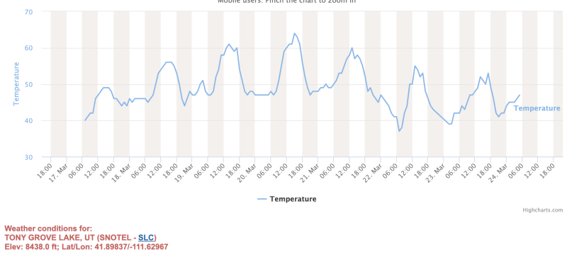
At 0600, the UAC Card Canyon weather station at 8700 feet reports 44°F and 44.5 inches of total snow. It's a sweltering 47°F at the Tony Grove Snotel, with 54 inches of total snow. On Logan Peak, winds are blowing from the west-southwest at 26 mph. It's 40°F on Paris Peak at 9500 feet, and the winds are from the southwest, blowing 23 to 29 mph. It will be mostly sunny today, and temperatures at the highest elevations in the Logan Zone will reach around 50°F, with moderate winds blowing from the west. Overnight, temperatures will stay well above freezing and in the mid-40°F range in most upper elevation areas again. This week, temperatures will climb back up into the "way too hot" or well-above-normal range until Thursday night, when another short-lived, dry cold front passes through, and freezing temperatures are possible.

Coverage is still good at upper elevations in the Central Bear River Range, though the snow is rough, dusty, and debris-covered.

Recent Avalanches

In the last few days across the Logan Zone, we've observed numerous natural wet avalanches caused by the extreme heat wave. Yesterday, I could see evidence of fresh wet avalanche activity in north-facing terrain off Logan Peak in Mill Hollow and Drop In, Drop Out in lower Logan Canyon, way above Zanavoo.

Find observations from the Logan Zone and from across the state HERE.

Avalanche Problem #1
Wet Snow
Type
Location
Likelihood
Size
Description

This morning, all mountain weather stations are reporting temperatures that are well above freezing, and the snow surface will quickly soften in today's heat. Loose wet avalanches involving saturated snow are possible in very steep, rocky terrain. Wet slab avalanches are also possible, as meltwater is percolating through the snowpack, actively weakening the snow above buried weak layers, pooling on crusts, and increasing the potential for large, natural avalanches. And, as slab layers soften in the heat, people are also more likely to trigger dangerous avalanches.

  • Pay attention to terrain traps below you, such as gullies or cliffs, where even a small avalanche can have severe consequences.
  • If you're sinking into the snow above your ankles, or you're seeing active roller balls, move to shadier or lower-angle terrain.
  • Avoid being on or under steep slopes with saturated surface snow and poor snow structure.
  • An example of what we are talking about when we mention wet slab avalanches.
  • Although wet avalanches are hard to predict, the video below shows potential for wet slab avalanches to propagate across a slope.
Additional Information
  • Travel with a partner, and cross or ride slopes steeper than 30 degrees one at a time while the rest of your group watches from a safe spot.
  • Ensure that everyone in the group has avalanche rescue equipment (a transceiver, probe, and shovel) and knows how to use it.

-----------------------------------------------------------------------------------------------------------------------------------------------------------------

For all questions on forecasts, education, Know Before You Go, events, online purchases, or fundraising, call 801-365-5522.

Did you know the UAC hosts a podcast? Episode 2 of Season IX is just out - AI, Machine Learning, and the Value of Expert Intuition at the Utah Avalanche Center.

Are you interested in learning more about avalanches? Visit our education page for details on all our classes.

For more information, visit the UAC weather page here: UAC Weather Page For Logan-specific weather, go here: Logan Mountain Weather

-Remember, the information you provide could save lives, especially if you see or trigger an avalanche. To report an avalanche or submit an observation from the backcountry, go HERE

-Receive forecast region-specific text message alerts to receive messages about changing avalanche conditions, watches, and warnings. Sign up and update your preferences HERE

This forecast is from the U.S.D.A. Forest Service, which is solely responsible for its content. This forecast describes general avalanche conditions and local variations always occur.

General Announcements
This information does not apply to developed ski areas or highways where avalanche control is normally done. This forecast is from the U.S.D.A. Forest Service, which is solely responsible for its content. This forecast describes general avalanche conditions and local variations always occur.