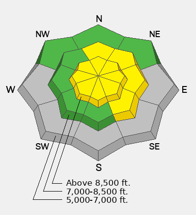
Your best bet for soft snow riding will be in high, sheltered northerly facing terrain, with cooler recent temperatures in the Northern Bear River Range, near and north of the state line. You might find nice, supportable spring-like "corn snow" on lower-angle sunny slopes, where saturated surface snow has now solidly refrozen and will soften during the day. Heightened avalanche conditions exist in all exposed upper elevation terrain due to the incessant strong winds from the west. Hard wind slabs that people could trigger will also likely be found in mid-elevation lee terrain facing north through southeast.
Much cooler temperatures and clouds kept the threat of wet avalanches low yesterday. Still, we observed some natural wet avalanches in the mountains from Sunday's and Monday's heat. Observers endured strong winds and found a wide variety of snow surface conditions in the Bear Lake Area backcountry on Monday. Here is the report from Bloomington Canyon.
The UAC Card Canyon weather station at 8700 feet reports 10°F and 60 inches of total snow. The Tony Grove Snotel, at 8400 feet, reports 16°F with 72 inches of total snow. At 9700 feet on Logan Peak, winds are blowing from the northwest 25 to 30 mph, with overnight gusts above 50 mph. Strong winds continue to blow from the west-northwest on Paris Peak, at 9500 feet, blowing 20 to 30 mph, with a gust of 54 mph last night. It's 7°F, and the wind chill value is -14°F.
Expect sunny skies today, with temperatures at 8500 feet climbing to around 31°F, and strong, increasing, and incessant winds blowing from the west-southwest. Once again, winds will increase during the day at all elevations, and gusts around 40 mph are likely in exposed terrain. Clouds will increase tonight, temperatures will drop to around 24°F, and winds will continue to blow from the west. Tomorrow, expect partly sunny skies with increasing temperatures and winds from the west. High temperatures at 8500' will soar to around 41°F, and continuing strong and gusty winds will blow from the west, even increasing another notch.
Observers found evidence of significant natural avalanche activity from last week in Bloomington Canyon (photo below). Natural rollerball swarms and loose wet avalanches were observed on many slopes earlier in the week. Find observations in the Logan zone and from across the state HERE.