Forecast for the Logan Area Mountains

Toby Weed
Issued by Toby Weed on
Saturday morning, December 19, 2020
AVALANCHE ACCIDENTS ARE LIKELY THIS WEEKEND!
Heavy snowfall and drifting Thursday night overloaded a preexisting persistent weak layer, and created dangerous avalanche conditions on many upper and mid elevation slopes. Drifting from intensifying southwest winds today will cause increasing danger in exposed terrain. Natural avalanches are possible, people are likely to trigger dangerous avalanches, and CONSIDERABLE danger is widespread at upper and mid elevations.
  • Avalanches could be triggered remotely or from a distance.
  • Stay off and out from under slopes steeper than about 30 degrees.
Low
Moderate
Considerable
High
Extreme
Learn how to read the forecast here
Special Avalanche Bulletin
AVALANCHE CONDITIONS REMAIN DANGEROUS FOR THE MOUNTAINS OF NORTHERN AND CENTRAL UTAH, INCLUDING THE WASATCH RANGE...THE WESTERN UINTAS, THE BEAR RIVER RANGE , AND THE MANTI-SKYLINE PLATEAU. RECENT HEAVY SNOWFALL AND DRIFTING FROM STRONG WINDS HAS CREATED AREAS OF UNSTABLE SNOW. HUMAN TRIGGERED AVALANCHES ARE LIKELY. TRAVEL IN AVALANCHE TERRAIN IS NOT RECOMMENDED. STAY OFF OF AND OUT FROM UNDERNEATH SLOPES STEEPER THAN 30 DEGREES
Special Announcements
Beaver Mountain is closed to uphill travel so the crew can set up for opening day on Tuesday.
Thanks to the generous support of our local resorts, Ski Utah, and Backcountry, discount lift tickets are now available. Support the UAC while you ski at the resorts this season. Tickets are available here.
Weather and Snow
Heavy snow accumulated and was drifted onto steep mountain slopes with Thursday's storm, overloading widespread sugary preexisting weak snow from November. Many natural and remote triggered avalanches where obsevered yesterday in the Logan Zone...
Before the storm most slopes had little more than about 2' of total snow, and a steep temperature gradient turned the shallow snow into loose sugary or faceted grains. In many places, the weak snow is easy to punch through to the rocks below.
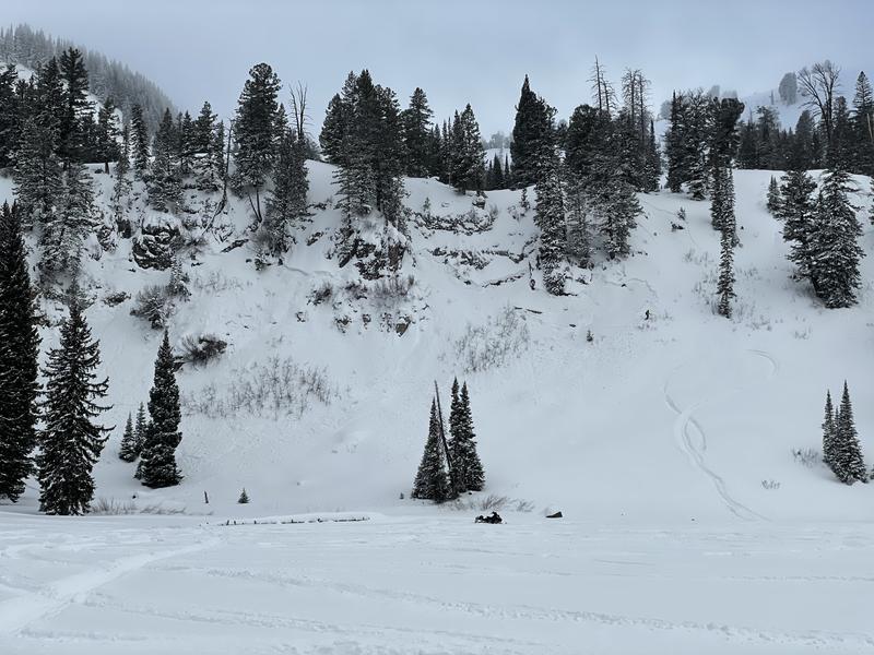
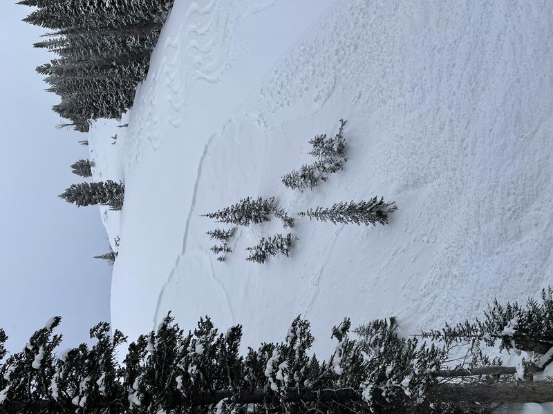
Numerous natural and remote triggered avalanches where observed in the Bear River Range yesterday. This one is on White Pine Knob. (ward)

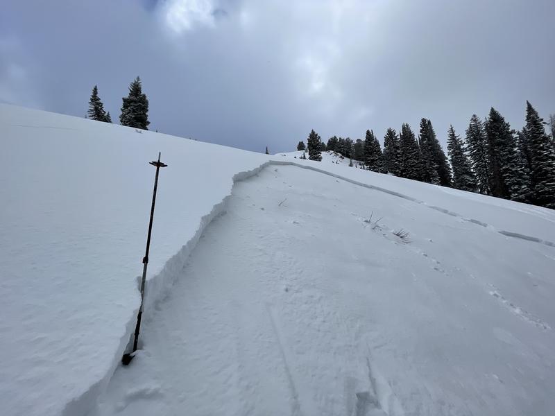
Expect mostly cloudy conditions in the mountains today, with a chance of some snow showers and intensifying west-southwest wind blowing along the ridges. Clouds will remain over the zone through the weekend and it will be pretty cold, with a chance for some more snow showers on Sunday. Looks like several inches of snow is possible on Tuesday and Tuesday night.
Recent Avalanches
Numerous natural avalanches ocurred Thursday night in the Tony Grove Area, and several "user friendly" avalanches were remote triggered by different parties in the area yesterday. The avalanches on north and east facing slopes from about 7500' up to 9000', were mostly about 1' deep, with some about 2', and 20' to 400' wide. These were all failing on faceted snow and running on the mid-November thermal crust, leaving 1 to 2' of very sugary snow in bed surfaces...
Tony Grove Lake
White Pine Knob
Check out this video of an intentionally triggered avalanche near Tony Grove Lake from Wednesday.
Ad
Avalanche Problem #1
Persistent Weak Layer
Type
Location
Likelihood
Size
Description
Many slopes in the region are plagued by layers of weak faceted snow formed during the prolonged November dry spell.
Avalanches failing on a persistent weak layer can be very sensitive, and they might be triggered remotely, from a distance, or worse from below!
A thick layer of very weak, sugary, or faceted snow will likely be a problematic persistent weak layer on many slopes, as future snow overloads it.
Avalanche Problem #2
Wind Drifted Snow
Type
Location
Likelihood
Size
Description
It will be rather windy at upper elevations and there is pleanty of powder for it to drift around. Natural avalanches are possible today, and people are likely to trigger dangerous wind slab avalanches, 1 to 2 feet deep on steep upper and mid elevation slopes where drifts formed and are building up today on weak, sugary, or faceted snow.
  • Even a small avalanche could be very dangerous due to shallow early season snow conditions. You do not want to get caught and carried over rocks or strained through bushes and stumps, so it's best to avoid travel on all steep drifted slopes.
Additional Information
Everybody should make time to examine and practice with your avalanche rescue equipment, and convince your backcountry partners to practice with you. Watch our companion rescue video HERE
My tip for avoiding avalanches in the backcountry is to keep your slope angles low. Avoid and stay out from under slopes steeper than about 30 degrees. Get a tool to measure slope angle and practice with it in the backcountry. Watch the video HERE.
General Announcements
Visit this website with information about Responsible Winter Recreation by the Utah Office of Outdoor Recreation.
We've kicked off Season 4 of the UAC podcast with a Conversation with American Avalanche Institute owner Sarah Carpenter. You can stream it HERE or wherever you get your favorite podcasts.
The Tony Grove Road is not maintained for wheeled vehicles in the winter.
EMAIL ADVISORY. If you would like to get the daily advisory by email you subscribe HERE.
Remember your information can save lives. If you see anything we should know about, please help us out by submitting snow and avalanche observations....HERE. You can also call us at 801-524-5304, email by clicking HERE, or include #utavy in your tweet or Instagram.
I will update this forecast by around 7:30 tomorrow morning.
This forecast is from the USDA Forest Service, which is solely responsible for its content. The forecast describes general avalanche conditions and local variations always occur.