Forecast for the Logan Area Mountains

Toby Weed
Issued by Toby Weed on
Wednesday morning, January 28, 2026

The avalanche danger is LOW. While unlikely, people could trigger small wind slab avalanches on drifted upper-elevation slopes, and loose avalanches of weak sugary snow are possible in steep, northerly-facing terrain.

Low
Moderate
Considerable
High
Extreme
Learn how to read the forecast here
Special Announcements

***Join us for a Backcountry 101 for snowmobilers this evening and tomorrow. This life-saving course is designed for snowmobilers and snow bikers taking their first on-snow avalanche class or looking to refresh previous training. For more information and to sign up, click here.

Weather and Snow

Snow surface conditions are quite variable across the zone. You can still find nice, recrystallized snow on northerly-facing and shaded slopes (best if low angle), and there are widespread crusts of varying thickness in sunny terrain. At low and mid-elevations, the snow cover is exceptionally thin, creating hazardous travel conditions due to rocks, downed trees, and barely covered branches. In most places, if you step off the trail, you sink through loose sugary snow to the ground. Lower elevation slopes facing southeast, south, southwest, and west are mostly bare of snow. Higher, the faceted snow has become so loose on steep, northerly-facing slopes that people can easily trigger sluffs or small loose avalanches. These are generally not an issue unless people are swept into trees or other terrain traps. Recent winds redeposited snow on top of weak faceted snow, creating isolated pockets of unstable snow in exposed upper-elevation terrain, primarily on slopes facing the eastern half of the compass (northwest through southeast). Today, people could still trigger small slab avalanches of wind-drifted snow.

This morning, at the UAC Card Canyon weather station at 8,700 feet, the temperature is 29°F, and there is 41 inches of total snow. The Tony Grove Snotel at 8400 feet reports 28°F and 54 inches of total snow. On Logan Peak at 9700 feet, winds are currently blowing from the south-southwest at 30 mph and gusting to 37 mph. It's 21°F on Paris Peak at 9500 feet, and the wind is blowing from the south-southwest 15 to 22 mph. There's a good chance of snow in the mountains today and tonight, with 2 to 6 inches of accumulation possible at upper elevations in the Central Bear River Range. Expected high temperatures at 8500 feet will be around 28°F, and moderate winds will blow from the west-southwest. Clearing is expected late tonight, with temperatures dropping to around 13°F, and a moderate wind blowing from the west-northwest will be enough to drift the fresh snow. Tomorrow will be mostly sunny, with a high near 27°F. Beyond that, dry conditions are expected to continue through at least the middle of next week.

Recent Avalanches

No avalanches have been reported recently. For all observations and avalanche activity in the Logan Zone, go HERE.

Avalanche Problem #1
Normal Caution
Type
Location
Likelihood
Size
Description

Traveling conditions are fast in the backcountry, and the tired out snow is generally stable. We're finding generally safe avalanche conditions, but remember, LOW danger doesn't mean there's NO danger. Now is a great time to get out in the mountains, explore new terrain, and practice companion rescue with your backcountry partners.

  • Watch for and avoid stiff drifts or wind slabs formed by redeposition on weak surface snow consisting of near-surface facets or surface hoar.
  • Small loose avalanches of sugary, faceted snow are possible on very steep slopes.
  • ***Travel with a partner, and cross or ride slopes steeper than 30 degrees one at a time while the rest of your group watches from a safe spot.
  • Ensure that everyone in the group has avalanche rescue equipment (a transceiver, probe, and shovel) and knows how to use it.
Avalanche Problem #2
Wind Drifted Snow
Type
Location
Likelihood
Size
Description

People might trigger small avalanches of wind-drifted snow where wind slabs recently formed on preexisting weak surface snow in exposed upper-elevation terrain.

  • Avoid and stay out from under stiffer pockets of recently drifted snow on steep slopes. (wind slab avalanches might be triggered remotely)
  • Wind slabs may have formed or have been cross-loaded in and around terrain features like mid-slope roll-overs, gullies, under cliff bands, or sub-ridges.
  • Suspect wind slabs are often chalky, rounded, and smooth, and they can sound hollow, like a drum. Shooting cracks and whumpfs obviously indicate instability.
Additional Information

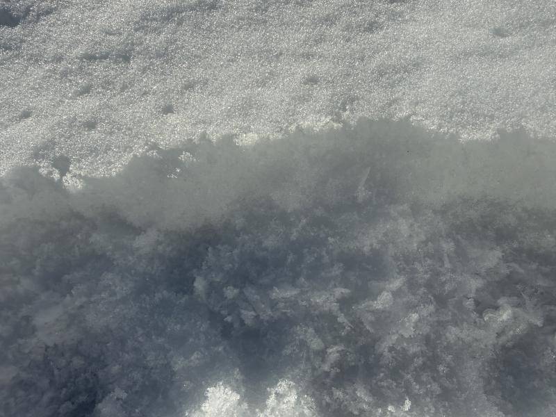
A layer of surface hoar and small near-surface facets is now capped, preserved, and the surface smoothed out by the little bit of snow accumulation from this weekend. Once buried by future snows, this will likely become a problematic, persistent weak layer.

Use safe travel practices: travel with a partner, and cross or ride steep slopes one at a time while the rest of your group watches from a safe spot.

Did you know the UAC hosts a podcast? Episode 2 of Season IX is just out - AI, Machine Learning, and the Value of Expert Intuition at the Utah Avalanche Center.

Are you interested in learning more about avalanches? Visit our education page for details on all our classes.

For more information, visit the UAC weather page here: UAC Weather Page For Logan-specific weather, go here: Logan Mountain Weather

-For all questions on forecasts, education, Know Before You Go, events, online purchases, or fundraising, call 801-365-5522.

-Remember, the information you provide could save lives, especially if you see or trigger an avalanche. To report an avalanche or submit an observation from the backcountry, go HERE

-Receive forecast region-specific text message alerts to receive messages about changing avalanche conditions, watches, and warnings. Sign up and update your preferences HERE

This forecast is from the U.S.D.A. Forest Service, which is solely responsible for its content. This forecast describes general avalanche conditions and local variations always occur.

General Announcements
This information does not apply to developed ski areas or highways where avalanche control is normally done. This forecast is from the U.S.D.A. Forest Service, which is solely responsible for its content. This forecast describes general avalanche conditions and local variations always occur.