Looking to up your avalanche knowledge? Want to feel more confident about making decisions in the backcountry with your group? Join us for a Backcountry 101 for snowmobilers on January 28 and 29. This life-saving course is designed for snowmobilers and snow bikers taking their first on-snow avalanche class or looking to refresh previous training. For more information and to sign up, click here.
Sunny slopes will remain firm/crusty until they soften with today’s warmth, while sheltered, shady, and northerly aspects still hold dry snow. Riding conditions are best in wind-protected terrain. With the next possible round of precipitation not until later this week, we are tracking the surface snow as it transforms into surface hoar, near-surface facets, and recrystallized snow - our subsequent weak layers.
The Tony Grove Snotel at 8400 feet reports 28°F and 57 inches of total snow. At the UAC Card Canyon weather station at 8700 feet, it's 24°F, and there is 43 inches of total snow. Currently at 9700 feet on Logan Peak, the wind is blowing in the 22 to 29 mph from the west. It's 23°F on Paris Peak at 9540 feet, and the wind is blowing 26 to 31 mph from the west southwest.
We have yet another beautiful day on tap in the mountains, with mostly sunny skies and 8500' temperatures reaching 31°F. Steady light winds will blow from the west-northwest, creating a wind chill around 10°F. The strong high pressure remains over the region through much of the upcoming week, with a continued temperature inversion keeping hazy conditions in the valleys and fair, unseasonably mild conditions in the mountains. There is some hope on the horizon, though, with a chance of measurable precipitation next Friday.
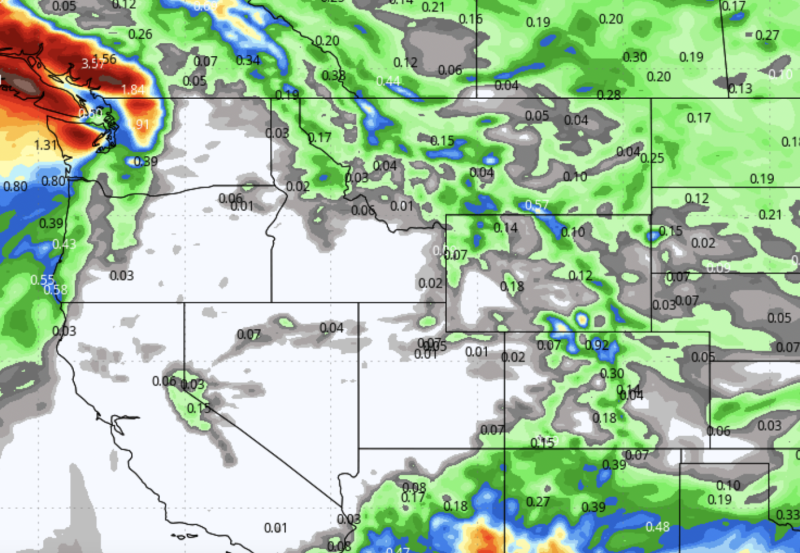
Cumulative precipitation through the end of January according to the GFS model run. The Intermountain West is not the
place ot be right now for fresh powder. Want some of that? Try Vermont. Jay Peak has received 268" of snow this season so far.
There were no avalanches reported yesterday. It has been over a week since the last significant avalanche report, a natural wind slab on Cherry Peak.
For all observations and avalanche activity in the Logan Zone, go HERE.


